Ferron Notom Delta Complex
1. Facies architecture and sequence stratigraphy of wide valley systems, Cretaceous Notom Delta complex, Ferron Sandstone, Utah.
2. Facies architecture of storm-flood dominated, hyperpycnal delta-fronts and prodelta deposits in lowstand versus transgressive systems tracts, Cretaceous Notom Delta complex, Ferron Sandstone, Utah.
3. Chemo-stratigraphy of asymmetric deltas and associated shelf mudstone deposits, Cretaceous Notom Delta complex, Ferron Sandstone, Utah.
4. Non-marine sequence stratigraphy of the Ferron Notom delta.
5. Seismic expression and reservoir modelling of the Ferron Notom Delta.
6. Correlation uncertainty in paralic and non-marine systems using sparse data sets.
Related Publications
Papers:
Bhattacharya, J and Davies, R (2001).
Bhattacharya, J, Zeng, X, McMechan, G, Aiken, C, Xu, X, Hammon III, W, and Corbeanu, R (2004).
Bhattacharya, J and Tye, R (2004).
Project 1: Sequence Stratigraphy and Facies Architecture of the Cretaceous Notom Delta Complex, Ferron Sandstone, Hanksville, Utah
The Last Chance delta complex of the Cretaceous Ferron sandstone in central Utah has been extensively studied both from the facies architectural and sequence stratigraphic perspective, and is widely used as a field training ground by industry. The Notom delta complex, superbly exposed farther to the south and east along the Burr Trail, and around Hanksville, Utah, has received far less attention. This area of Utah is even more arid than the classic Ferron exposures around the San Rafael Swell resulting in even better continuous cliff exposures, which are perfectly suited to 3D reservoir characterization studies (Fig. 1 and 2).
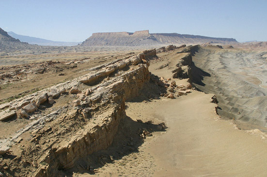
Figure 1. General view of Ferron sandstone exposures near Hanksville Utah. Note the almost complete lack of vegetation and the extensive and continuous quality of the outcrops.
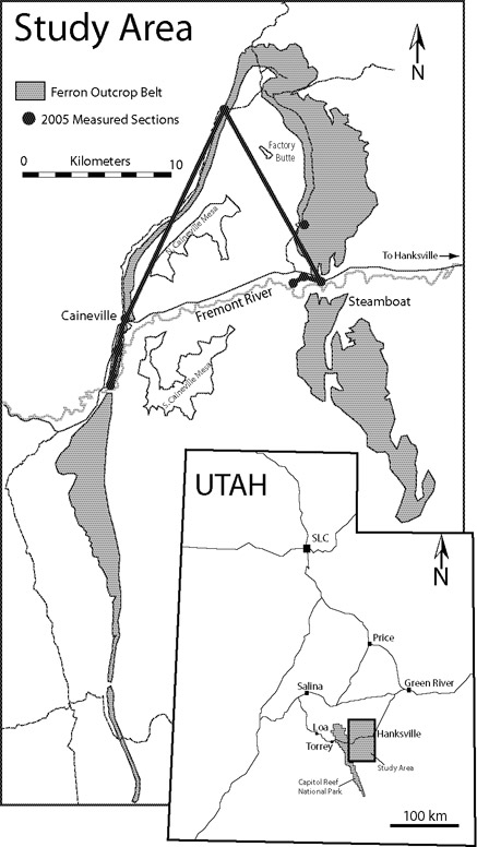
Figure 2. Base map showing outcrop belt, measured sections and location of preliminary cross-section shown in Fig. 5, below.
Preliminary scouting, conducted in the Summer of 2004 and data collected in the summer of 2005, shows a wide variety of complex facies and syndepositional features, including fluvial, wave- and storm-dominated delta fronts overlain by possible incised valley feeder systems to the delta. We propose an initial field study to begin a detailed sequence stratigraphic analysis of this unit.
Outcrops just west of Hanksville show upward-coarsening delta fronts that internally consist of a complex series of lens-shapes, scoured HCS storm beds interbedded with lightly burrowed mudstones, suggesting a strong storm-fluvial influence (Fig. 3). The relationship of these fluvial-storm influenced facies to adjacent wave-dominated and more homogenous shorefaces will be tested using the recently developed asymmetric model for wave-influence deltas.
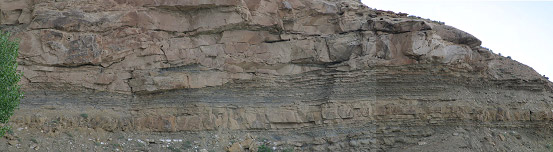
Figure 3. Heterolithic, storm-influenced, fluvial-dominatedv delta front.
These storm-dominated delta fronts show striking similarities to Tertiary-age storm-dominated delta fronts in places such as offshore Trinidad, and these may represent excellent outcrop analogs.
Incised channelized systems overlying these delta fronts and shorefaces show complex internal geometry, associated with overlapping channel bars (Fig. 4). We are particularly interested in determining the relationship between storm-flood-dominated delta fronts and the associated feeder systems.
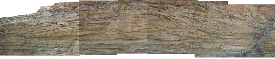
Figure 4. Overlapping bars within Ferron channels showing complex internal architecture of sandstones and mudstones, Ferron Sandstone, Hanksville, Utah.
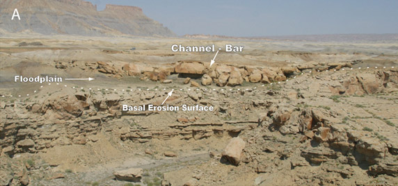
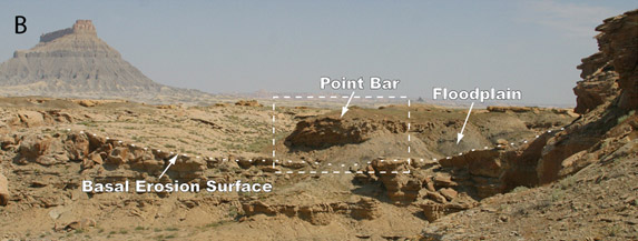
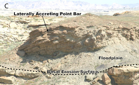
Figure 4. A. The undulating erosion surface likely represents a sequence boundary marking the base of a fluvially-cut valley. The valley is overlain by floodplain mudstones and channel-bar sandstones. B. This photo connects to the right of 4A., and shows the continuation of the basal erosion surface as well as laterally accreting bar deposits in the overlying valley fill. C. Close-up of the point bar deposits overlying the floodplain. More details of the bars are shown in figure 3.
During field work in the summer of 2005 I collected 6 vertical measured sections over a 180 square mile area (Figs. 2 and 5). I measured about 1,600 feet of section spaced 1.5 to 10 miles apart. The measured sections show that the Ferron is about 100 m (300 feet) thick and consists of up to 7 deltaic to shoreface marine parasequences passing upward into a fluvial succession characterized by sandy to conglomeratic fluvial channel belts and coaly floodplain mudstones. The proportion of non-marine versus marine facies increases to the south and west. Paleocurrents vary from northwest, north and northeast to southwest, suggesting the delta was fed by rivers flowing form the southwest.
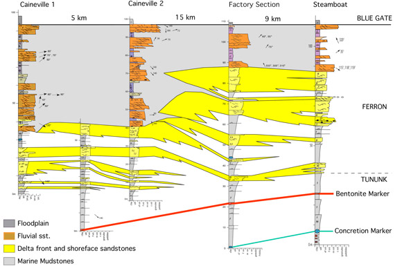
Figure 5. Regional cross section showing decreasing non-marine facies to the east and illustrating basic style of parasequence stacking.
Major, multistory channel deposits indicate valleys that cut into underlying shoreface and deltaic sediments. These are candidate sequence boundaries, which should allow detailed examination of the transition of sequence boundaries laterally and from proximal to distal location. There are opportunities for mapping valleys and documenting their internal archtecture as well as examining strike variability of a major mixed-influence delta. The delta appears to be storm, wave, and flood influenced, although rare tidal cross stratification was observed, suggesting limited tidal influence.
I supervised 6 students working on various aspects of these projects.